Storm Dylan wind warnings upgraded to amber alert on Hogmanay


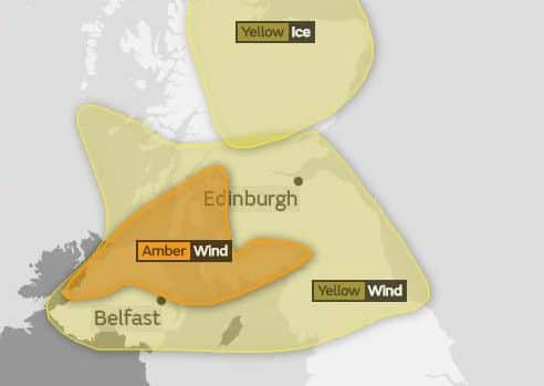
The Met Office have upgraded their weather warning for parts of the west coast and south west of Scotland to amber on Sunday 31 December, between 04:00 - 13:00.
Amber means residents in the affected area should be prepared to change plans and “protect you, your family and community from the impacts of the severe weather.”
Advertisement
Hide AdAdvertisement
Hide AdStorm Dylan is forecast to sweep in from Ireland to lash southern Scotland early on Hogmanay - although the winds should subside in time for the bells.

With gusts of up to 80mph expected in Northern Ireland and southern Scotland, forecasters warned there is the potential for “injuries and danger to life from flying debris”.
It comes after heavy snow, rain, thunderstorms and wind caused disruption across much of Britain on Friday as the country was gripped by another day of wintry weather.
A change in conditions on Saturday will see milder weather move in from the south and west, although cold air over northern parts will mean an icy start.
Advertisement
Hide AdAdvertisement
Hide AdSouthern England and the Midlands could see temperatures rise to 15C (59F) as the day progresses, although Scotland may continue to see hill snow.
A yellow warning for wind has been issued for Northern Ireland and Scotland on Sunday, as Dylan begins to roll across the region in the early hours.
The Met Office said there is a “small chance of damage to buildings”, as well as power cuts and potentially issues with mobile phone coverage.
“Large waves and beach material being thrown on to coastal areas could also be a hazard,” the forecaster added.
Advertisement
Hide AdAdvertisement
Hide Ad“There is a small chance of longer journey times or cancellations as road, rail, air and ferry services are affected, with the chance that some roads and bridges could close.”
Meteorologist Alex Burkhill said: “The good news is the worst of the weather will clear by midnight for the New Year’s Eve celebrations.
“It will be a chilly night, but not exceptionally cold and the breeze might blow a few fireworks in slightly different directions but it shouldn’t cause too many problems.”