Storm Gareth: ‘Hurricane force’ winds expected to hit Scotland
and live on Freeview channel 276
The seventh-named storm of the winter season has the potential to be the most damaging yet, registering ‘hurricane force’ on the Beaufort Scale.
Winds will begin picking this afternoon and evening, it is overnight into Wednesday morning when they are expected to reach their peak.
Advertisement
Hide AdAdvertisement
Hide AdThis could mean the closure of road bridges to high-sided vehicles, with aircraft left out of position as they may be unable to land at their planned destination.
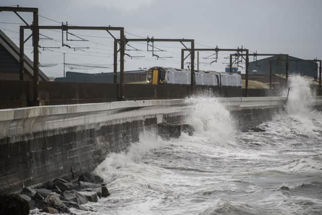

The whole of England, Wales and Northern Ireland has been placed under storm warning, meaning airports all over the UK will be affected.
Ferries are believed to be most vulnerable to the atrocious conditions, particularly services on the west coast.
Ferry operator Cal Mac has warned passengers to expect a swathe of delays and cancellations today due to stormy seas.
Power cuts are also a possibility.
Advertisement
Hide AdAdvertisement
Hide AdThe Met Office has posted a yellow ‘be aware’ warning for severe gales in south west Scotland, Dumfries and Galloway, Lothian and Borders, Ayrshire, Dunbartonshire and Argyll. It kicks in at 9pm and lasts until 3pm on Wednesday. But although they are not in the warning area, parts of north west Scotland will see some of the worst conditions.
Fans of Aberdeen FC face a grueling trip home following the Scottish Cup replay with Rangers at Ibrox in Glasgow.
Gareth is tracking to the north west of Scotland, the product of cold temperatures in the US fuelling a very strong Jetstream.
Bonnie Diamond of the Met Office said: ”Tuesday begins with clear spells and some blustery showers but the winds start to pick up later in the morning.
Advertisement
Hide AdAdvertisement
Hide Ad“These will become severe gales by early evening, when wind speeds of between 70 and 80mph can be expected on the west coast of Scotland.
“Over higher ground and on exposed parts of the west coast, the wind could get even higher than that.
“Inland, the west of Scotland could see winds of 60 to 70mph.

“Winds gradually begin to ease on Wednesday morning but it will remain a windy day across all parts of the UK.
Advertisement
Hide AdAdvertisement
Hide Ad“They don’t properly die down until evening and I’m afraid Thursday is expected to be another windy day.
“It just seems we are in line for a procession of low pressure systems coming in from the Atlantic.”
The mild conditions experienced in February have encouraged many plants and trees to flower early. This could make them vulnerable to high spring winds and cold temperatures.
One gardening expert also fears Storm Gareth will become a ‘blossom buster’, ripping off the early flowering of sloes and cherry plums.
Advertisement
Hide AdAdvertisement
Hide AdGeorge Anderson of the Beechgrove Garden TV show advised gardeners to move pots of daffodils to safe locations and to ensure they securely tie down any covers they have in the garden.
Mr Anderson said:”Any young trees which are newly-planted and not rooted-in are liable to be given a good shake and will need to be checked after this storm.
“Pots of daffodils will have to be moved to a secure location.
“Some fruit trees like sloes and cherry plums are in full flower now. The wind will desiccate the flowers and may result in a poor crop.
Advertisement
Hide AdAdvertisement
Hide Ad“Most other fruit trees like apple, pear and plum are not flowering yet so they may be OK.
“Anything loose in the garden has to be secured. I have a cherry tree in flower and I just know it’s going to be belted by the wind.”