New St Kilda Viewpoint to bring history of island closer


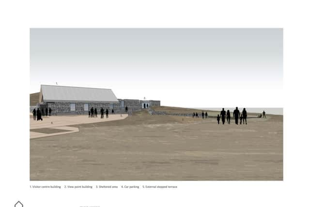
A group in North Uist has received outline planning permission to build the St Kilda Viewpoint near Balemartin on the slopes of Beinn Riabhach.
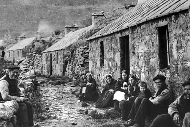
Those behind the Sealladh Hiort project claim North Uist has the best views of St Kilda, whose community was finally evacuated in 1930, from anywhere in the inhabited outer Hebrides.

Advertisement
Hide AdAdvertisement
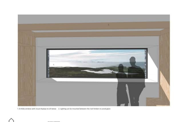
Hide AdThe centre will offer a dramatic vantage point of St Kilda, which sits around 45 miles out into the Atlantic, with hopes to use technology – including infrared and a webcam – to connect the two sites when the poor weather inevitably rolls in.
The centre will be one of three in the Outer Hebrides to form the trail, with the centrepiece development due to be built at Uig on the Isle of Lewis. A third attraction is planned for South Harris.
David Newman, secretary of the Sealladh Hiort project, said: “There is a great amount of community support here for the project and everyone is right behind it.
“We were looking for a new site and walked up to Beinn Riabhach and you just have the most fantastic views from there. The land where we want to build has been donated by a local family who were desperate for something to be done with it. They are very enthusiastic about what is happening.
Advertisement
Hide AdAdvertisement
Hide Ad“We realised that the higher up we went, the better the view, so we have stuck our necks out a bit. Rather than build it down by the road, we have taken it up 200 to 300 metres to this most spectacular position.”
The centre’s main building will host displays relating to life on the isolated community, whose members survived largely on sea birds and wild fowl eggs. The population peaked at around 180 in the mid-19th century and fell away to 36 by the time it was evacuated.
Exhibits at the centre will include a St Kilda post bottle which was used to ferry messages sealed tight in a canister and wooden box, and floated using a sheep bladder.
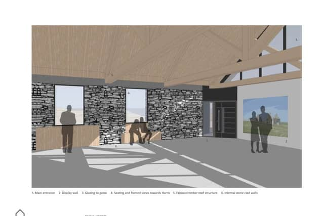
From a separate viewpoint building, visitors will be able to view St Kilda and Boreray, the Monachs, Hasgeir, Vallay, Udal, Pabbay and other Sound of Harris islands.
Advertisement
Hide AdAdvertisement
Hide AdMr Newman said: “All of these islands have a common history – all of them were once inhabited, but are now empty. We are also taking a look at what links St Kilda and other Hebridean islands in terms of their social and physical histories. Although St Kilda was isolated, life there was similar to life on other islands.”
Talks are now underway with the National Trust for Scotland, which owns St Kilda, and the Ministry of Defence, which has had a tracking station on Hirta island since 1957, over the use of technology to link the Unesco World Heritage site with the North Uist centre.
It is hoped that a webcam will relay pictures of the sea cliffs and wildlife on Hirta while infrared imaging could create an image of St Kilda even when visibility is poor.
A track will also be built to help people of all abilities ascend part of Beinn Riabhach to enjoy the views which extend to Wester Ross and the Cuillins on Skye on a clear day.
Advertisement
Hide AdAdvertisement
Hide Ad“We really want to give access to everyone so they can enjoy this wonderful environment,” Mr Newman added.
The North Uist centre is expected to cost somewhere in the region of £1.5 million with an ambition to open it during 2020. Funding is being sought from early next year.
The project’s origins lie in a public competition in 2009 to identify the best site in the Western Isles for a “remote access” St Kilda Centre. Uig on Lewis was chosen as the main site with North Uist and South Harris to become satellite attractions.
Bold illustrative designs for Uig, drawn up by Dualchas Architects on Skye and Oslo-based Reiulf Ramstad Architects, were unveiled in 2016. The budget for the Uig centre has now been reduced from an estimated £8m to around £5.5m.