The mystery of Edinburgh’s Oxygen Street - and why you can never go there


One of the city’s secrets has a name - Oxygen Street. The thoroughfare is hidden in some of Edinburgh’s maps, but you won’t be able to find it if you go searching in real life. Here’s why.
Where is Oxygen Street?
Simply speaking, Oxygen Street doesn’t exist. It’s actually a fictitious street, dreamed up by a mapmaker in an attempt to copyright their work.
Advertisement
Hide AdAdvertisement
Hide Ad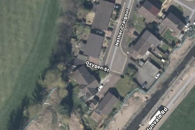
However, that hasn’t stopped Apple Maps from including it on its app. In the iOS map, Oxygen Street does appear to be a real place - found in someone's garage at the end of the Nether Craigour cul-de-sac.
Describing its maps, which launched in 2019, Apple said, “The new map features significantly improved and refined details for roads, beaches, marinas, parks, buildings, airports and more.”
It appears that this “significantly improved” map has been designed to include red herrings in the form of fake places. On Google Maps, there is no such place as Oxygen Street in Edinburgh.
However, Google Maps has fallen folly to trap streets in the past - notably, in 2009, in Lancashire, England, you could easily find a small town called Argleton online, which didn’t exist in real life.
Advertisement
Hide AdAdvertisement
Hide Ad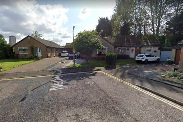
But why are printed maps and their digital counterparts being populated with fictitious streets?
‘Trap’ streets
In cartography, a ‘trap’ street is a purposeful error a mapmaker includes in their map - be it in the form of an entirely fake street, or a street with the wrong name - in order to catch out anyone who was copying their work.
The idea is that the copyright violators would be caught out when questioned about the trap street in their copied map, as they would be unable to explain where the fictitious street came from, or why it was included.
Trap streets are generally non-existent, but sometimes they are real streets, just slightly altered in a way that will still catch out copyright violators, without stopping anyone from using the map for genuine navigation purposes. Instead of a fake street, there might be an extra bend in the road that’s not really there, or the street looks narrower than it does in real life.
Trap streets across the UK
Advertisement
Hide AdAdvertisement
Hide AdTrap streets are hidden throughout the UK. The BBC programme Map Man, which aired in 2005, claimed that the London A-Z featured around 100 trap streets.
Of all the trap streets, Moat Lane is probably the most well known - a fictitious street in Finchley that actually made it on to Google Maps. Google Maps is based on the Tele Atlas Directory which supplied their initial framework, according to Gizmodo, and this little Easter egg seemingly slipped through the cracks.
Legal cases
Trap streets have been used in legal cases - for example, in 2001, the Ordnance Survey of Great Britain took the Automobile Association (AA) to court over copyright infringement.
The Ordnance Survey of Great Britain claimed that the AA was using Ordnance Survey maps as the source material for their maps. A team of Ordnance Survey experts identified the unique features in their publications that proved that the AA had indeed been using their maps as their source.
Advertisement
Hide AdAdvertisement
Hide AdOrdnance Survey’s chief executive, Vanessa Lawrence, said, “There are design elements in the way we show things which are not obvious to either the user or the copier. When we see the two versions side by side, we can spot clues.”
As a result of the case, the Ordnance Survey of Great Britain won a £20 million payout from the AA.