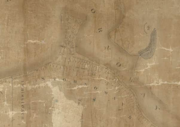
220-year-old map from the Hebrides is saved


The map, which dates from 1800, has been rescued by conservators at National Library of Scotland after being sent to the mainland by Western Isles Libraries.
Chapman’s Plan of Stornoway Bayhead is considered an important historical document given the level of topographic and personal information it holds.
Advertisement
Hide AdAdvertisement
Hide AdDetails include the names of the occupants of all the houses in Stornoway in 1800.
It also shows the surrounding settlements of Imrisligach and Inaclete and planned work that was never carried out there.
Chris Fleet, map curator at National Library of Scotland, said the map had “major value” for those researching the history of the island and those who lived there.
He added: “This is the earliest surviving detailed map of the town of Stornoway, and related settlements of Imrisligach and Inaclete.
Advertisement
Hide AdAdvertisement
Hide Ad“The central streets are named, and buildings are clearly shown. Each numbered plot of land has been carefully measured in acres, rods and falls.
“The map proposes new developments, not all of which took place. Inaclete has been carefully laid out in a grid plan with three parallel streets; there is no evidence that this was constructed.”
Chapman was hired by Francis Mackenzie, 1st Baron Seaforth and chief of Clan Mackenzie, as Chamberlain of Lewis, between the late 1790s and about 1810.
He became an important figure in the development of the island and oversaw the creation of 34 crofts on Bernera in the north west.
Advertisement
Hide AdAdvertisement
Hide AdThey are “probably” the earliest crofts created in the Outer Hebrides, Mr Fleet said.
Chapman’s original Survey of Lewis, which dates from 1807 to 1809, is lost but later versions do survive.
The 1820 map arrived in Edinburgh to be digitised and put on-line but its poor condition meant the process could not go ahead without significant conservation work.
Mr Fleet said the document had been heavily conserved in the past, leaving the paper stained, skinned and distorted, with many large cracks and tears obscuring the information contained in the map.
Advertisement
Hide AdAdvertisement
Hide AdConservation of the map was led by conservator Claire Thomson after funding was secured from the Aurelius Trust.
The Chapman map of Stornoway can be viewed in full at: https://geo.nls.uk/mapdata3/189530621_1/openlayers.html
The full story of how the map was conserved can be read at: https://blog.nls.uk/conserving-the-map-of-stornoway-by-james-chapman-ca-1800/
